Download Maps From Google
Advertisement

LandMap Vivo v.10 10
Create GPS enabled geo maps directly on the background of aereal photos and road maps from the internet. Import geodata from Google-Earth, OpenStreetMap, GPS tracks and GPS logger. Map editor , manually digitizing.
Advertisement
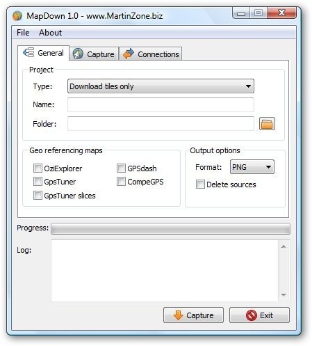
MapDown v.1.01
Capture maps from major internet map providers (Google Maps, Yahoo Maps, Microsoft Live, Openstreetmap), create georeference files for PDA application like OziExplorer, GPS Tuner, GPSdash, CompeGPS.
Offline Map Maker v.7.5
Offline Map Maker is a tool that help you to get offline tile images from Google Maps, Yahoo maps, Bing maps, Ovi maps and openstreetmap.
Picasa
Find and enjoy the pictures on your computer in seconds.A free software download from Google.Picasa is software that helps you instantly find, edit and share all the pictures on your PC. Every time you open Picasa, it automatically locates all your
PanoraMioDesktop Random v.1.9 Beta
PanoraMioDesktop is a wallpaper changer for you to use. PanoraMioDesktop is an wallpaper changer that download random images from Google Earth and set them as wallpaper each X minutes.

Drive On v.1.4.0.0
Drive On Drive On Beta provides multi-language turn-by-turn voice activated navigation and other necessary and convenient features to makes your drive enjoyable. • Choose Maps from Bing or Google • Touch & hold any location in the map to drop

MapCache v.3.0.0.0
MapCache provides you with fully offline maps from OpenStreetMap. ● Fully functional ad-supported trial (ads removed in paid version) ● Compass and current heading indicator ● Route tracking, save to gpx format and upload/download from

Simple OSM v.2.10.0.0
Simple OSM is a reliable application to display maps from the OpenStreetMap (OSM) project. In the beginning, there were just a small number of features, but until now lots of cool things have been added: several other map layers (e.g. Bing,

OpenMapper v.2.0.0.0
Use maps to find details about anywhere on earth and most places in the solar system. Dozens of map sources from Google, Bing, and Open Streets to maps provided by NASA, NOAA, and governments at every level. Unlike other map applications,
Acute Photo EXIF Viewer v.1.0
View photo and image metadata (EXIF, IPTC/NAA, etc.). Supports many photo and image formats including most raw formats. Features include drag and drop, printing and ability to show GPS location (geotag) from Google Maps. Portable application.
Share Stuff v.1.5
Share Photos with Google Photo and flickr. Share Event Schedules with Google Calendar and InfoMan. Easily upload and download Photos with descriptions between Share Stuff, Google Photos, Yahoo flickr, and Facebook.